These web pages present contemporary sources in an attempt to sort out the confused story of the massacre of British army officers near the village of Mahua Dabar, south of Basti in northern India, in June 1857, and the subsequent reprisals by the British. Please note that I have not (except for the substitution [N-word]) changed the quoted texts, which very often display 19th-century attitudes and terminology, plus a wide variety of attempts to transliterate local names and other words. However, I have sometimes added my own comments and clarifications [in italics in square brackets].
This supplementary prologue page describes the township as it was before 1857. The main narrative of the Mahua Dabar massacre can be found here.
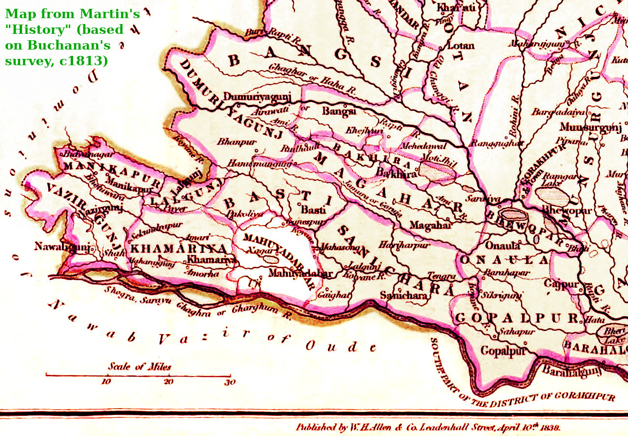
p377 [here bullet-listed to distinguish text about the whole Mahuyadabar Police Circle from text about individual villages; please note also that details are based on Francis Buchanan's survey of the area, made around 1813]: "MAHUYADABAR- Very much resembles Sanichara, that is, it has a bare sandy tract on the side of the Ghaghra, and several stunted forests in the centre, and along the northern boundary. The whole, however, is as well cultivated as the western parts of Sanichara, and the plantations as moderate as there, although many still are superfluous. There are many small pools, and one of some consequence named Chanda Tal [FOOTNOTE: "Tal generally signifies a marsh ..."], which at the end of the rainy season is reckoned 1½ coss long, and one broad. The Raja has in his house one room of brick. There are 100 houses of two stories with mud walls; 70 are covered with tiles, and 30 are thatched. There are 200 huts with mud walls and tiled roofs. Of the remainder, all thatched with grass, 31 parts have mud walls, and one part walls of hurdles.
p344-5 [Goruckpoor district]: Purgunuh Nugur [i.e. Nagar; by this time, Mahua Dabar seems to have lost its status as the head of any administrative district], Hindoo agricultural population: 47,417 M, 41,281 F; Hindoo non-agricultural population: 14,493 M, 12,368 F; Mahomedan [etc.] agricultural population: 3,300 M, 3,023 F; Mahomedan [etc.] non-agricultural population: 4,120 M, 3,600 F. Total: 129,602
Purgunuh Bustee, Hindoo agricultural population: 59,734 M, 53,311 F; Hindoo non-agricultural population: 14,719 M, 13,558 F; Mahomedan [etc.] agricultural population: 7,060 M, 6,376 F; Mahomedan [etc.] non-agricultural population: 2,619 M, 2,375 F. Total: 159,752
[Population of Goruckpoor town, 54,529, Jungul Punouna, 15,592; Mahua Dabar had a population below 5,000, but so did over 13,000 other places in Goruckpoor district for which no detailed figures were given, so it is impossible to state whether the population was 4,999 or 1.]
MAHUYADABAR, in the British district of Goruckpore, lieut.-gov. of the N. W. Provinces, a small town on the Manaura, a feeder of the Koyane, and with it ultimately discharged into the Ghagra. Buchanan [Nearly half a century before this book was published!] describes Mahuyadabar as a straggling place, buried in plantations, and containing 200 houses, many of which are tiled, and some have two stories. Distant S.W. from Goruckpore cantonment 40 miles. Lat. 26° 34', long. 82° 44'.
p468 footnote [on the village of "Mahwah-dabur" where the British officers were killed]: "This was a Mahomedan village, held by a family that had discharged the office of Kagee" [more commonly spelled Kajee, or Kazi, from the Arabic for a judge; this might explain why Mahua Dabar in Buchanan's time was the centre of a Police Circle]
[PS: A tantalising thought:]
"A NOTE ON THE PRE-MUTINY RECORDS IN THE OFFICE OF THE COMMISSIONER OF THE GORAKHPUR DIVISION" p4: "The Basti district formed part of the Gorakhpur district until 1865. Most of the Basti pre-mutiny records are therefore in the record room of the Collector of Gorakhpur and, as in the case of the Azamgarh district, records relating to Basti occur in the offices of the Commissioners of the Gorakhpur and Benares divisions.
On the formation of the Basti district a number of pre-mutiny settlement records were transferred to the record room of the newly formed district.
These settlement records have been bound up in 82 volumes and fall into six
series.
Series I. Village statements of the year 1830 ... 29 volumes.
II. Annual jama statements of 1830 ... 6
III. General statements in acres of 1830 ... 9
IV. Police jagir registers of 1830 ... 8
V. General village registers of 1830 ... 3
VI. Plans of villages surveyed in the year 1836, 27
The best page to read next is probably this one about the ejection of British officers from Faizabad in 1857.