
The Newport TowerThe first of these maps, from an original made by Vesconte de Magiollo (or Maiollo) in 1527, is one of the very earliest published records of the coastline between New York and Cape Cod- recording the discoveries of a French-sponsored expedition led by Italian navigator Giovanni da Verrazzano. The relevant section is shown here, with two key names highlighted, both of which have been linked to the Newport Tower. The first problem you'll notice is that they can't both refer to the tower, because they are a significant distance apart. In fact, at the scale of the map, the distance between them is probably 100 to 200 kilometres. 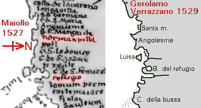 Several manuscript copies exist of a letter from Verrazzano to his sponsor, King Francis I of France, giving details of the voyage. The text of one version was published in the 16th century in Ramusio's "Delle Navigationi et Viaggi", and translated into English shortly afterwards by Richard Hakluyt. However, that version was very incomplete, to the point where many doubted its authenticity, so in 1841, the New York Historical Society published a text and translation of another, longer version from the Biblioteca Magliabechiana, Firenze, Italy- part of that text is reproduced below, with my own translation. Later, another manuscript turned up, known as the "Cellere Codex"; this was acquired by the Pierpont Morgan Library, and a translation by E.H. Hall was published in 1910 (you can also see a later translation here). The important thing about the Cellere manuscript was that it retained Verrazzano's original marginal notes, which explained many of the names he had given to features along the coast. The notes make it easier to interpret maps like Maiollo's, because they match names to descriptions in the letter. Hence "B. Sa. Margarita" immediately above "Norman villa", can be identified from its description as New York Bay. Here's Verrazano's description of the next stage of the journey: Several manuscript copies exist of a letter from Verrazzano to his sponsor, King Francis I of France, giving details of the voyage. The text of one version was published in the 16th century in Ramusio's "Delle Navigationi et Viaggi", and translated into English shortly afterwards by Richard Hakluyt. However, that version was very incomplete, to the point where many doubted its authenticity, so in 1841, the New York Historical Society published a text and translation of another, longer version from the Biblioteca Magliabechiana, Firenze, Italy- part of that text is reproduced below, with my own translation. Later, another manuscript turned up, known as the "Cellere Codex"; this was acquired by the Pierpont Morgan Library, and a translation by E.H. Hall was published in 1910 (you can also see a later translation here). The important thing about the Cellere manuscript was that it retained Verrazzano's original marginal notes, which explained many of the names he had given to features along the coast. The notes make it easier to interpret maps like Maiollo's, because they match names to descriptions in the letter. Hence "B. Sa. Margarita" immediately above "Norman villa", can be identified from its description as New York Bay. Here's Verrazano's description of the next stage of the journey:
"Levata l'ancora navicammo verso l'oriente che cosi la terra tornava, discorse leghe ottanta. Sempre a vista di quella discoprimmo una isola in forma triangolare lontano dal continente leghe X di grandezza simile alla isola di rodi piena di colli, coperta d'alberi, e molto populata per li continui fuochi, per tutto intorno al lito vedemmo che facevano. Battezzammolo in nomine della vostra clarissima gentrice. Non surgendo a quella per la opposizione del tempo venimmo a un' altra terra distante dalla isola leghe XV trovammo uno bellissimo porto"... "Raising the anchor we sailed towards the east, as the land turned, covering eighty leagues. Always in sight of the land, we discovered an island, triangular in shape, 10 leagues from the mainland, of similar size to the island of Rodi [which usually means Rhodes in the Aegean, but there's nothing of similar size to that on this coast, and it's a bit odd that an Italian navigator would use a Greek island as a comparison for a French king] full of hills, covered with trees, and very populous, judging from the continuous fires we could see they made around all the shores. We baptized it in the name of your most excellent mother [Louise of Savoy]. Not anchoring there, because of the opposition of the weather, we came to another land at a distance of 15 leagues from the island, finding a most wonderful harbour" ... [Here follows a detailed description of the country and inhabitants around this harbour, where the expedition stayed for 15 days]... "Questa terra e situata nel paralello di Roma in gradi 41 2/3 ma alquanto piu fredda per accidente, non per natura, come in altra parte narrero a V.S.M. descrivendo al presente il sito di detto paese, qual corre del oriente ad occidente, dico che la bocca del porto guarda verso lo austro angusta mezza lega dipoi entrando in quello infra oriente e settentrione s'estende leghe XII dove allargandosi causa uno amplissimo seno di circuito di leghe XX in circa nel quale sono V isolette di molta fertilita e vaghezzi piene di alti e spatioso alberi infra le quali isole ogni numero di classe senza timore di tempesta o di altro impedimento di fortuna sicura puo quiescere." "This land is situated on the parallel of Rome- at latitude 41 2/3 [degrees], but somewhat colder- by accident, not by nature, as I shall recount to Your Serene Majesty in another part, describing at present the situation of this country, which runs from east to west; I say that the mouth of the harbour [a marginal note in the Cellere Codex adds "which we called the Refuge because it was so wonderful" ('Refugio' in the original Italian)] looks towards the south with narrows half a league wide, after which you enter into it- on the east and north it extends 12 leagues, broadening to become a huge haven 20 leagues in circumference, within which are 5 small islands, of great fertility and prettiness, full of tall and broad trees- by which islands any size of fleet could rest secure, without fear of tempest or other obstacle of fortune." So our voyagers have headed east from New York Bay along the southern shore of Long Island, have found Block Island so alluring that they failed to explore, or even comprehend, Long Island Sound (and later they fail to discover the curl of Cape Cod as well, probably because they are so worried about the surrounding shoals), and have arrived at Narragansett Bay- then they have christened the whole bay "Refugio". In other words "Norman villa" is not the Newport Tower, because it's somewhere in the vicinity of Long Island (and it's probably not a villa either, but an Italian rendering of the French "ville", a settlement- just as Louise of Savoy's island appears on the map- upside down- as "Luisa"); and "Refugio" is not the Newport Tower, because it's a great big bay. Verrazzano goes into great detail about the 15 days of exploration around the 'Refugio'- there were plenty of circular buildings, but made of bent saplings roofed with straw matting. No stone structures (and a reference much earlier in the voyage makes it clear that the explorers were specifically looking for such things)- no towers. In fact, just after the above extract, there is a specific reference to the defence of the "Refugio": "Nel mezzo della bocca si trova uno scoglio di viva pietra dalla natura prodotto atto a fabbricarvi qual si vuole machinna o propugnacolo per custodia di quello." "In the middle of the mouth can be found a reef of living rock, a product of nature, suitable for erecting any weapon or small fortification you want for guarding it."
The illustration, here making a second appearance for your convenience, shows both a version of the 1527 mapping by Magiollo, and a simplified outline from the 1529 map by Gerolamo de Verrazzano, who had accompanied his brother on his expeditions (and saw him killed in 1528). Gerolamo's place-names differ in many cases from those on the 1527 map- "Norman villa", for example, is replaced by the Italian family name "Tolomella" (unless there's a transcription error in the edition I used for the names). You will see that his coastal outline differs in some significant ways as well; for example the distance between the New York bay and Luisa island is considerably shorter, putting the island in the entrance to a large rounded bay, presumably representing all the expedition saw of Long Island Sound; evidently Magiollo realised the distance was wrong, but added coastline in the wrong place- east of the bay (which he shows, somewhat smaller than Verrazzano, near the "Norman villa") instead of west. That difference between the two maps is why we can't be very precise about the distance from "Norman villa" to "Refugio".
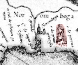
Further along the coast, there are numerous other differences between the two maps, including the appearance of one very insignificant name on the 1529 version, somewhere near the modern Canadian border, which was neither French nor Italian but transcribed from conversation with local inhabitants: Oranbega.  Shortly after Verrazzano wrote his report to the King of France, Portuguese navigator Esteban Gomez set off on his own voyage along the same coast (possibly in the opposite direction) sponsored by the Emperor of Spain. Among other things, he noticed what appeared to be a huge estuary somewhere in the vicinity of Verrazzano's "Refugio"- but this estuary was hundreds of kilometres long, contained many small islands and reefs, and had a really wide mouth. Furthermore, Gomez found that the coast on the southwest side of the estuary bent right round to make a big peninsula, with islands/reefs on its seaward side. The mapmakers chose to show these features running south to north- but almost certainly, Gomez' big estuary is actually Long Island Sound, and the peninsula is Long Island itself.
However, there were plenty more explorers to follow, including an anonymous sea captain from Dieppe whose 1539 report (published in Giovanni Battista Ramusio's massive compilation "Navigazioni e Viaggi") gave the alleged native name for the great territory Verrazzano and Gomez had skirted: Norumbega. Curiously though, a couple of years later in 1541, the names "A norumbega" and "A norombega" [the A may be the first letter of the name, or it may just stand for "Aestuarium"- Latin for estuary] appeared on Gerardus Mercator's beautiful globe, identifying, not the region, but Gomez' big estuary and the next estuary to the east. Then, apparently in 1542, French/Portuguese navigator Jean Alfonse de Saintonge (or Allefonsce, Alphonse, etc.), sailed south-west along the coast from Newfoundland, past a big estuary which he identified as "Norumbergue" to a bay at 42 degrees latitude. After returning to France he compiled a "Cosmography"- effectively an explorers' guide to the world [abbreviated and retitled for publication as "Les voyages avantureux du capitaine Jean Alfonce Sainctongeois", but an edition from the original manuscript was published in 1904 as "La Cosmographie: avec l'espère et régime du soleil et du nord", edited by Georges Musset] in which he described the estuary, mentioning reports that there was a native town some distance upriver which had a thriving fur trade. Alfonse's latitude figures for places which are still known are accurate to within half a degree. If he sailed south-west from Newfoundland and passed the estuary on the way to the bay at 42 degrees, then his "Norombergue" can't be either of the estuaries on Mercator's globe, which are further south- but that didn't stop mapmakers from indicating a substantial settlement on the major estuary within a few months of Alfonse's return (sample here from a French map of 1543, west at the top again). The explanation of this extreme vagueness is likely to be a variation of the "Canada effect". Just as the huge country of Canada is named from the local dialect word for "village", so it has been suggested that every time sailors reached the limit of safe navigation in an estuary and asked the local inhabitants what was beyond, the answer sounded like "norumbega".
 All of which brings us, after a long struggle, to the second alleged cartographical appearance of the Newport Tower- a "tiny tower shown at the mouth of today's Narragansett Bay" on Gerardus Mercator's great world map of 1569.
Oh yeah? Here's the relevant section of the map (north at the top this time), larger than life-size unless you're viewing this on a really small screen. First problem- as discussed above, "today's Narragansett Bay" is almost certainly to the east of the big estuary- perhaps that smaller narrow-mouthed estuary just below the pink inset on the picture (indeed, to confuse things yet further, Mercator has placed the island named by Verrazzano after King Francis's mother even further east, and nowhere near any big estuaries- bottom right in the picture here- and accidentally named it 'Claudia', after Francis' wife Queen Claude). Furthermore, Mercator has altered the shape of the huge estuary from its earlier triangular shape to something looking more like a very large version of Narragansett Bay- so what the heck, let's assume that that is what we're supposed to be discussing. There's no obvious "tiny tower", but he shows an island at the mouth of the Bay, and an elegant real-estate development some distance upriver (on the opposite bank to the 1543 French map; note also, for amusement's sake, the word 'arrecifes' next to it- a slightly mobile relic of Gomez' report of reefs in the estuary!). Mercator has indicated the native town with the sort of symbol he would use for a significant settlement in Europe, complete with church steeple. Incidentally, it also looks suspiciously as if cartographers by this time had some vague information about the Hudson river (which of course is the only genuine major river along that stretch of coast) hence the fork north of the town. I've included a second version of the estuary as an inset, just to make it absolutely clear that if you think you're seeing a little tower standing near its mouth, either it's pretending to be an island or your eyes are playing tricks on you. By now you'll have realised that pretty much every pre-colonial reference to Narragansett Bay has been seized upon at some time to back a theory about the origin of the Newport Tower, and one of the most recent is based on the early colonial efforts of the English. Backers of an expedition organised by Sir Humphrey Gilbert in 1583 were granted 1,500,000 acres of land to the west of the bay with the five islands described by Verrazzano (which for promotional purposes had been named the Dee River, after the influential scholar John Dee). Further evidence that the British made use of the bay before the establishment of the Rhode Island colony is shown a few paragraphs down this page, but what would be the purpose of building something like the Newport Tower in this situation? If you build an isolated structure, designed with wooden beams supporting a floor over an open arcade, in semi-unknown territory with a native population, if it comes under attack everybody in it is going to die. Here's a claim I have to quote at some length to demonstrate the magnitude of its incompetence, from a contribution to a Sinclair genealogy web forum (yes, that's Sinclair as in Rosslyn Chapel etc., but just don't get me started, OK). Following an unhelpful presentation of the Mercator map nonsense, the writer continues: "Another was made by the Dutchman Cornelis Hendriexson before 1614 and which was later included in his Atlas published in 1635 The original map was found in the Dutch archives of The Hague in 1841. This map shows the islands and coast of Narragansett Bay, with one small area on the east side of the bay marked 'New England', the only part of the map with an English name. On this map a 'Toret' is shown as a small circle on the Western end of Newport Island." It's based on work by Arlington Mallery in the 1950s, and in order of appearance the problems with it are:
The same forum contributor also mentions another claim by Arlington Mallery, about a chart made in 1614 by the legendary British explorer John Smith, showing a site he believed to be an English settlement, at the location where Newport was later established, and which he later christened 'Old Plymouth'. Unfortunately, I have not yet found this chart; Smith's famous published map of New England does not include Narragansett Bay, and in his published account of his exploration he specifically states that the allegedly wealthy regions south-west of Cape Cod "I went to discouer this last yeare: but because I miscarried by the way, I will leaue them, till God please I haue better acquaintance with them". However some light may be thrown on the matter by the last of our problematic early maps: 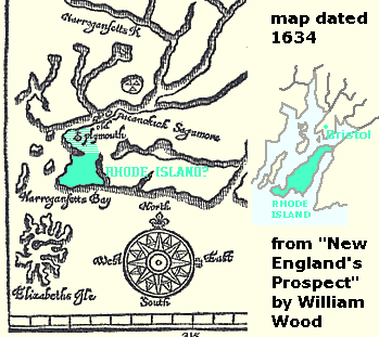 Some people date it to 'the 1630s', and some by logical approximation to '1630' (which would conveniently be two years before the Chesterton windmill) but it actually has '1634' in big figures at the top. It's from the front of a book by William Wood called "New England's Prospect: A true, lively, and experimental description of that part of America, commonly called NEW ENGLAND"... (London, John Bellamy, 1634). This too marks the mysterious place called 'Old Plymouth', which some have identified as a settlement around the Newport Tower. However, comparison with the detail from a modern map at right on the illustration suggests that 'Old Plymouth' is more likely to be at the north end of Rhode Island, or even (if you take the two inlets at the limits of the area I have shaded in solid green to be the channels bounding the Island) in the area of the modern Bristol. Bear in mind also an important fact which far too many people ignore when discussing North American history- the Pilgrim Fathers were not the first Europeans to make a settlement there! Apart from ventures such as Jamestown, there were numerous trading posts and centres for the fishing industry. Any commercial voyager who found Verrazano's beautiful 'Refugio' would make a note of it as a very useful port in a storm, particuarly if the local inhabitants remained as friendly as they had been to Verrazano's crew. So, 'Old Plymouth' as pre-Pilgrim trading port, no problem; 'Old Plymouth' in the vicinity of modern Newport, no way. Some people date it to 'the 1630s', and some by logical approximation to '1630' (which would conveniently be two years before the Chesterton windmill) but it actually has '1634' in big figures at the top. It's from the front of a book by William Wood called "New England's Prospect: A true, lively, and experimental description of that part of America, commonly called NEW ENGLAND"... (London, John Bellamy, 1634). This too marks the mysterious place called 'Old Plymouth', which some have identified as a settlement around the Newport Tower. However, comparison with the detail from a modern map at right on the illustration suggests that 'Old Plymouth' is more likely to be at the north end of Rhode Island, or even (if you take the two inlets at the limits of the area I have shaded in solid green to be the channels bounding the Island) in the area of the modern Bristol. Bear in mind also an important fact which far too many people ignore when discussing North American history- the Pilgrim Fathers were not the first Europeans to make a settlement there! Apart from ventures such as Jamestown, there were numerous trading posts and centres for the fishing industry. Any commercial voyager who found Verrazano's beautiful 'Refugio' would make a note of it as a very useful port in a storm, particuarly if the local inhabitants remained as friendly as they had been to Verrazano's crew. So, 'Old Plymouth' as pre-Pilgrim trading port, no problem; 'Old Plymouth' in the vicinity of modern Newport, no way.
The Sinclair forum contributor also mentions various textual references, the most notorious of which is probably the so-called "Plowden Petition"- an official document in the English National Archives. For a very simple demonstration of why this is as incorrect as all the above-mentioned claims about maps indicating the Newport Tower, see Doug Weller's article about the Tower in the ever-informative Hall of Ma'at website, which also discusses other aspects of the problem. Here, for convenience, are the most significant passages of the petition (actually the first of two requests for land grants, the second being for a much larger area) and its associated description of the existing and proposed "commodities" on the island: The petition by Plowden and other "adventurers" made about spring 1632, asks for the grant of "a remoate place w'thin the Confines of Virginia some 150 myles Northwards from the Savages, & James Citty w'thout the bay of Chisapeak and a conuenient Isle there to be inhabited called Manitie, or Long Isle in 39 degrees of lattitude, and within the bounds of Virginia abutting on the Ocean Eastwards 18 myles and of the Continent Westwards neere Dellawars Baye, and not formerly graunted". The land requested also includes "30 myles square of the Coste next adioyning to be erected into a County Palatine called Syon." [Public Record Office, London. Colonial Papers vol. VI, no. 60; my transcript from photograph] "The Commodities of the Island called Manati ore Long Isle w'thin the Continent of Virginia" describes the island as well wooded and watered, with abundant wildlife, and explains how colonists would utilise it: "26. By vnitie and societie of Partners, securetie and hope of gaine growes if order and dissapline and intelligence w'th the savages Verginea on the South New England on the North, the Dutch plantation 60 miles on the west be had. 27. So that 30 idle men as souldiers or gent be resident in a rownd stone towre and by tornes to trade w'th the savages and to keep their ordinance and armes neate ..." [Public Record Office, London. Colonial Papers vol. VI, no. 61; transcript from "Collections of the New York Historical Society for the year 1869"] Comparing the Plowden documents with the earliest detailed chart of the Delaware Estuary area, made about 1639 by Joan Vinckeboons, and another early map , "VIRGINIA AND MARYLAND As it is Planted and Inhabited this present Year 1670", by Augustine Herrman, it seems most likely that the long island discussed in the documents was one then existing (but since split up by sea erosion, probably in the early 18th century) between the estuaries of Great Egg Harbor and Little Egg Harbor, including the site of Atlantic City N.J. The native name "Manitie" is simply a phonetic rendering of the Lenape word for "island"; the Dutch plantation (i.e. colony) would be Fort Nassau, just south of modern Camden N.J., some 60 miles overland (though only 50 as the crow flies) from Little Egg Harbor. 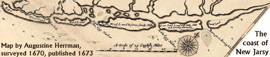
Below is a crude map of my own to illustrate another textual reference: the will of Governor Arnold, claimed in James Savage's "Genealogical Dictionary of the First Settlers of New England" (1860: vol. 1 page 67), on unknown evidence, to have been "the richest man in the Colony". Some people have doubted that the "stone built Wind-mill" referred to in the will is actually the Newport Tower at all, but its context in the document is as a reference for the location of the Arnold family burying ground, which still exists next to 70 Pelham Street, Newport, so the stone mill must certainly have been very close to the Newport Tower... This crude plan is not based directly on maps of Newport, because I am not sure which modern streets mark the estate boundaries; also the claimed length of the Arnold plot from the one fairly certain street reference- the "town street", now Thames Street, is significantly shorter than the actual distance to the mill- but longer than the distance to the mill as given on the earliest printed map of Newport (by Charles Blaskowitz, 1776-7), which suggests a discrepancy in definitions of the old-fashioned measurement units. What is certain is that when John Banister, the husband of Hermione, daughter of Freelove Pelham (nee Arnold) who inherited the estate from Governor Arnold, was writing his will in 1767, just a few years before the earliest confirmed depictions of the Newport Tower (such as this view from the north, about 1775, with height slightly exaggerated, and a combination of squashed perspective plus omission of minor details which suggests the artist may have been some distance away, using a telescope) he too referred to an old "stone mill some time past used for a powder house". 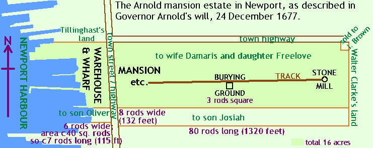
Just before we leave the Governor's will, a brief philosophical discursion. The 1677 will, and the Jewish cemetery deed of the same year which refers to Touro Street as "the highway that leads from ye stone mill", do appear to be the earliest documents mentioning the existence of the tower (claims that the mill was mentioned in the diary of John Hull, treasurer of the Massachusetts Bay colony, in 1665, are based on a misinterpretation of an intermediate source, as can be seen by consulting the published transcript of the diary in "Transactions and Collections of the American Antiquarian Society" vol. III, 1857). There is no known record of the building of the Tower, which is one reason for the claim that the Newport Tower predates the Colonial era. If records of the building of the mansion and warehouses mentioned in the Governor's will exist, then this is potentially a valid argument- otherwise, it's another total waste of time.
A postscript to the earlier "powder house" reference. Benson Lossing's "Pictorial Fieldbook of the Revolution" (1850: vol. 1, chapter 27) makes the claim that the Tower had formerly been significantly taller, but British troops retreating from Newport in 1779 had tried to blow it up. However, there is no evidence, either in old pictures or in the structure of the mill, for blast damage, and indeed the official report by the incoming Major General Gates to Congress, 27 October 1779, stated that "the enemy did not commit any wanton destruction upon their leaving the island; the batteries and defences towards the sea line only being demolished"- they even left large quantities of hay which they could easily have burned. Lossing is also responsible, in footnote 35 to the same chapter, for the following statement: "it is asserted that the Indians, of whom Mr. Coddington and other early settlers upon Aquitneck (now Rhode Island) solicited information concerning the structure, had no tradition respecting its origin." Two centuries after Coddington and his companions settled in the area, this is the very first published suggestion that the Native American population might have been aware of the existence of a stone tower before the foundation of Newport in the 1630s. But just look at those words: we are not told who made the assertion to Lossing, the claim that the Tower existed before Newport was established is probably part of the assertion, and what we are told, probably quite truthfully, is that the First Nations knew nothing about the Tower's origin. The real reason for that is quite likely to be because it was just one among hundreds of buildings created during the first century of Newport's development, not because it was built beyond the span of their collective memory. The fact that it suddenly appears in documents in 1676-7 is troubling to some people, for it seems unlikely that it could have been built just before then as Rhode Island was embroiled in "King Philip's War" from 1675-6. That, however, brings us to another potential early reference to the mill, in "The History of Philip's War" by Thomas Church (Boston, J. Frost, 1827- uses text of 2nd edition, Newport, 1772; first edition was published at Boston, 1716), telling of the exploits of his father, Benjamin Church. The anecdote in question is given on pages 47-48: to expedite a plan to attack the headquarters of native leader Weetamore, a party from the garrison at Mount Hope, Bristol, RI, proceeds to the shore of the cove two miles south-west. Given the small number of men available, the commanding officer has grave doubts about the attack plan, so Mr Church sarcastically recommends him to "lead your company to yonder windmill on Rhodeisland, and there they will be out of danger of being killed by the enemy, and we shall have less trouble to supply them with provisions." Two important points about this sentence: First, the word "yonder"- i.e. the windmill was visible from the shore near Bristol, which the Newport stone mill was not; one of the earliest detailed maps of the island, dated 1777, marks a windmill on the ridge above Arnold's Point, near the Bristol ferry landing, which is probably on the site of the one Church indicated- so in that sense the passage is not helpful. Second, the indication that the soldiers will be out of danger if they cross from the mainland to the island, and that it will be easier to feed them there- clearly indicating the role the island played in supplying food to the mainland settlers during the war. Newport, on balance, actually benefited from the war, thanks to its island situation, and it would not have been unreasonable for an entrepreneurial man like Arnold, owner of a very substantial estate, to built a showy new windmill to cash in on the demand for food from mainlanders whose farming was seriously disrupted. For many years there seemed to be good circumstantial evidence for the contention that the design of the Newport Tower is directly inspired by the Chesterton windmill, which at first glance it does indeed resemble. If you look in the International Genealogical Index (at least in its old microfiche version) you'll see an entry stating that Benedict Arnold was born at Leamington in Warwickshire, just a few miles from Chesterton, in 1615. Then again, you'll also see an entry claiming that he was born on the same day at the generally accepted family home of Ilchester in Somerset (and on some websites you'll see attempts to resolve the problem by inventing a Leamington in Dorset, close to Ilchester). The solution (which I took an embarrassingly long time to spot) is that there is a little village in Somerset, right next to Ilchester, called Limington or Lymington, which seems to have been the home of Benedict's parents while they were raising their family. The parish register for 1615 has been lost, and the information about Benedict's birthplace in the family's own records was apparently misspelled.
The latest attempt to offer evidence of a pre-Colonial date for the Tower comes from the "Chronognostic Research Foundation". In the autumn of 2007, having funded two archaeological excavations around the Tower, which apparently produced nothing of significance earlier than the 17th century, they announced that the surest clues to the date of the tower were the astronomical alignments of the various oddly-placed windows. 20 years earlier, Dr. William Penhallow of the University of Rhode Island (since retired) had demonstrated the existence of some two dozen significant alignments in the Tower, including midsummer sunset, and the "minor standstill" of the Moon. He pointed out to the Chronognostic researchers that such alignments, also found in ancient structures like Britain's great stone circles, would have been important for calculating the dates of religious festivals- right up to 1457, when almanacs, previously available only in manuscript form, began to be printed and circulated widely. Therefore, the Tower has to predate 1457, right? Wrong. Almanacs only solved part of the problem. The whole calendar was inaccurate, because it had leap years too frequently. Understanding the movement of the Sun was the key to calendar accuracy; and the key to accurate measurement of the Sun's movement was, as the ancient builders of Stonehenge understood, to use a very large measuring instrument. From 1475 onward, churches began to be equipped with small holes in the wall, through which a beam of sunlight would shine onto the floor at midday. Although the calendar was corrected in some countries from 1582 (to the modern "Gregorian" system), the elegant patterns traced by the sun on the church floors through the year were worth keeping for their own sake, and in the 17th century, as astronomy became fashionable thanks to the work of scientists like Galileo, more churches had the solar movement calculators built in. According to science historian J.L. Heilbron (in his book "The Sun in the Church") the peak period for this fashion began around 1650- almost exactly when Newport was being developed. As it happens, there is a possibility that most or all of the alignments in the Newport Tower are accidental (in the same way that "ley lines" can be found on a computer-generated map of a random imaginary landscape); but even if they are deliberate, they are likely to be the products of 17th century fashion. And finally... In 1643, the co-founder of the Rhode Island colony, Roger Williams, published a book called "A Key Into the Language of America" (transcript here, by F.R. Higgins of Amherst). This was based on his years of friendly contact with the Narragansett people, and it included not just details of their language, but also a great deal of information about their culture and their view of the world around them. One thing it does not include, however, is a single word about a mysterious stone tower on Aquidneck Island. There is an old academic saying, "absence of evidence is not evidence of absence"- but in history, there is always at least a partial absence of evidence, and part of the job of the historian is to decide when that absence is significant. The absence of the Newport Tower from a detailed first-person study of the native population around Narragansett Bay in the 1630s is, as absences go, probably not insignificant. For a good bibliography of works about the Newport Tower, see: http://www.redwoodlibrary.org/tower/millmenu.htm.  |