Email me

A CLOSER LOOK AT THE GREENLAND PROBLEM


Of all the remarkable features of the Vinland Map, the one which made cartographic historian R.A. Skelton most concerned that it might be a forgery was the depiction of Greenland. As other evidence (some of which was, after Skelton's untimely death, revealed to be mendacious) convinced him that the Map could not be a forgery, he devoted considerable effort to explaining how the Norse settlers might have explored and mapped pretty much the whole of Greenland's coast. Other commentators felt that he was worrying too much, and that the resemblance seemed less striking on close examination.

VM and 20th century Greenland outlines

It can, very properly, be said that the resemblance of the Vinland Map version of Greenland to the actuality as known from modern surveys is only superficial. The comparative outlines here are provided to demonstrate that it may not be quite superficial enough for coincidence. The two maps selected for comparison, though they look very different in detail, are taken from the same page (p20: maps of the North Pole region, on what appears to be a Zenithal Equidistant projection) of "Harmsworth's New Atlas of the World", published in the UK about 1922; all I have done is reduce them to outlines, and adjust their scale. The differences in detail are due to the size of the originals: the middle (blue) one was very small on the atlas page, the right (black) one much larger and more detailed. Note in particular how the small version exaggerates capes and fjords to the same sort of degree as the Vinland Map.

The island of Greenland is over 2,500km from north to south, nearly 1,500km from east to west. Its north end is so near the North Magnetic Pole that magnetic compasses are useless for determining direction. But take a look at the map outlines below, which have had a comparison frame added (a line joining the north, east, south and west extremities of the Vinland Map's depiction of Greenland, with the three other points where the overall trend of the coast's direction changes significantly). With the identical frame superimposed on the other two maps, it becomes apparent that the overall proportions of the middle map are, apart perhaps from the top left corner, almost identical to the Vinland Map version (and I have added an extra bit of the original map to the right-hand outline, to hint at a possible reason for the VM needing to be a bit imprecise at the top left of Greenland- it would be impossible to survey that part of Greenland without also detecting the coast of Ellesmere Island, the only other large landmass visible from the Greenland coast). On most maps of the 15th century, only the Mediterranean area is mapped with such overall accuracy, with Britain (much, much smaller than Greenland) typically shortened north-south, Scandinavia and the Baltic scarcely guessed at. So how come the Vinland Map portrays Greenland with its major changes of coast direction almost exactly matching an early 20th century map?

VM and 20th century Greenland outlines with comparison frame

A couple of points in conclusion. First, I'll leave you to decide how many individual fjords and capes can plausibly be matched between the VM and the 20th century maps. Second, and directly related, please note that I'm not claiming here that the VM Greenland was based on the small map in the Harmsworth Atlas. The chances of a forger who is likely to have been working in Italy or Spain owning one of the three early 20th century British atlases I happen to have on my bookshelves are slim, to say the least. But if the Harmsworth Atlas artist chose to exaggerate certain features in the shape of Greenland when working at a very small scale, other cartographers may have done the same, and may well have produced something even closer to the Vinland Map version.


The green outline superimposed on the details here is taken from the "Cantino" world map of c1501, which famously includes a big, strange island south-west of Greenland. Unfortunately, both this and the related Canerio (Caveri) map of c1503 stop too far south to see whether Greenland was visualised as an island, but its apparent derivatives by Martin Waldseemuller, the "Admiral's Map" of 1513 and the "Carta Marina" of 1516, both show Greenland as a peninsula joined to the north of the Eurasian landmass.Greenland- the Cantino mystery
Cantino and Vinland Maps- the North Atlantic
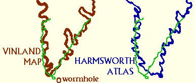
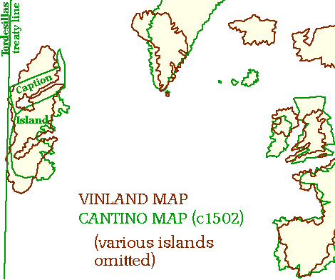
The comparison above was intended only to show how the angles of southern Greenland matched on the Vinland and Cantino maps. When you try to match the scale as well (which is difficult because they depict many features very differently, so I've just tried matching the vertical scale through Spain and France) things get really intriguing. There is a good match of positions for both Greenland and the Atlantic island on the Cantino Map (which has a large caption scroll at its northern end) conveniently placed just on the Portuguese side of the colonial boundary line agreed in the Treaty of Tordesillas after Columbus announced his new discoveries. Furthermore, the little island shown off the southern tip of Greenland in the Cantino map, but non-existent in reality, corresponds remarkably well with the strangest wormhole in the Vinland Map, which the worm gave up on almost as soon as this page had been eaten through. It seems we are being asked to believe that the Vinland Map was one of the Cantino map's sources- but the fact that the Tordesillas boundary falls just on the right side of the Atlantic island/Vinland implies that the VM must also have been available to the Portuguese during the treaty negotiations.

And there's more- what is going on with the more northerly of the two inlets shown on Vinland? Are we seeing a very long inlet with a basin at its head (like Lake Melville on the Labrador coast), or a lake drained by a very wide river (bearing in mind that even the Nile is shown on the Vinland Map by a single line)?
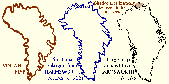
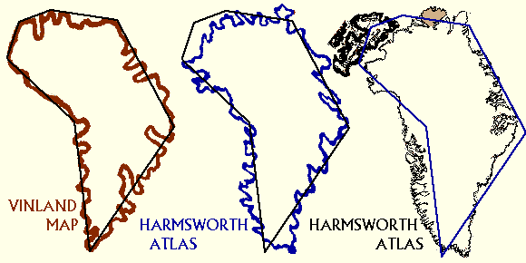
On Baffin Island is a large, quite shallow lake, containing hundreds of little islands, called Nettilling Lake. This lake is drained by a rather remarkable river, the Koukdjuak. Although less than 80km long, this river is about 2km wide for most of its length- much wider than the Nile at Cairo; nearly twice the width of the Mississippi at Baton Rouge, and comparable to the St. Lawrence at Quebec. The river drains westward, not east, but by simply turning Vinland upside down, and comparing with a modern map (based on my W.H.Smith World Atlas, 1982 edition), here's what we get:Lake on Vinland Map & 1982 atlas
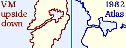
Matters become slightly more complex, however, as we go back in time. Here's a sequence of maps from 1955 (about the latest that could possibly have been used in drawing the Vinland Map) back to 1912 (an arbitrary choice, just because I happen to have two atlases from that year).

If the lake/inlet on the Vinland Map is a cheeky reference to Nettilling Lake, its trefoil shape seems to be based on a 1950s map, not a map from the 1930s or earlier.
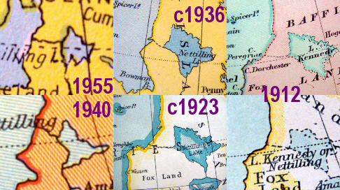
Lake in 20th century atlases