South America and the Dragon's Tail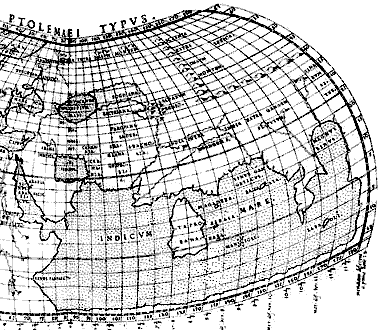 Roman geographers had calculated co-ordinates for thousands of places throughout Europe, Asia and northern Africa, and copies of one major geographical work, by Ptolemy, survived to become the basis of new maps in the middle ages. Though some aspects of Ptolemy's work are very impressive, the maps which were based on his co-ordinates contained some very bad mistakes, one of which was the assumption that Africa was the north end of a southern continent on the same scale as Asia, which it actually joined in the vicinity of Cambodia, giving a landlocked "Indicum Mare" (see the thin strip of land along the bottom border on the map at right). This contradicted the traditional medieval view that the sea between Africa and Asia joined a world-encircling Ocean, so when Andreas Walsperger attempted to revise the traditional world map to include Ptolemaic information in 1448, he chose to represent east Asia (correctly) as a large promontory, not joined to Africa. In 1486, Bartolomeu Diaz confirmed that the join did not exist, by sailing along Africa's west coast until he rounded its southern end and started heading north-east along its eastern coast. Roman geographers had calculated co-ordinates for thousands of places throughout Europe, Asia and northern Africa, and copies of one major geographical work, by Ptolemy, survived to become the basis of new maps in the middle ages. Though some aspects of Ptolemy's work are very impressive, the maps which were based on his co-ordinates contained some very bad mistakes, one of which was the assumption that Africa was the north end of a southern continent on the same scale as Asia, which it actually joined in the vicinity of Cambodia, giving a landlocked "Indicum Mare" (see the thin strip of land along the bottom border on the map at right). This contradicted the traditional medieval view that the sea between Africa and Asia joined a world-encircling Ocean, so when Andreas Walsperger attempted to revise the traditional world map to include Ptolemaic information in 1448, he chose to represent east Asia (correctly) as a large promontory, not joined to Africa. In 1486, Bartolomeu Diaz confirmed that the join did not exist, by sailing along Africa's west coast until he rounded its southern end and started heading north-east along its eastern coast.
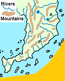
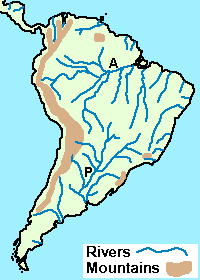
Why? What was the reasoning behind the inclusion of the curious protruberance at the end of the tail? Curiously, it bears a resemblance to a real geographical feature- but one which was thousands of miles from the Indian Ocean, and apparently undiscovered by Europeans until years after Martellus' map was made, Tierra del Fuego at the southern tip of South America. Not only that, the east coast has a bend at about the same latitude as South America. Not only that, but on Martellus' map the major river (which I've marked as A) is somewhat to the north of the bend, while the only east-coast river shown with a tributary (P) is somewhat to the south. Could these be the Amazon and Parana rivers, as seen on the more recent map below?
|