
North America- who knew about Hudson's Bay?Around the turn of the 16th century, European explorers and traders were finding new routes and places at an astonishing rate. It is generally accepted that Christopher Columbus was not, in 1492, the first European to discover land on the other side of the Atlantic Ocean. His importance is that he was the LAST person who had to set sail across the Atlantic with no idea what lay ahead, because so many others heard of his success. Famously, however, he never accepted that he had not reached the Indies, but a separate continent, which would later be named America. Matters were further confused for mapmakers because at about the same time, explorers were reaching the real Indies by sailing round Africa into the Indian Ocean. By the early 1500s, geographers were, as they thought, receiving information about eastern Asia both from trans-Atlantic explorers and from Asian sources. Both sets of information agreed in some respects- notably that the eastern coast of the continent ended with a large cape in the Arctic- but disagreed in others- the coastline which would later be known as northern Brazil did not fit with Asian geography at all. 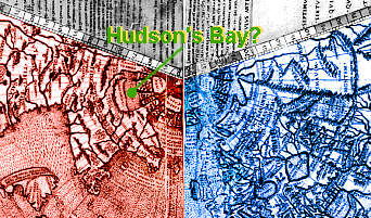 Cartographers were also trying to come to terms with the novel idea of sailing west to go east, and one map projection devised to convey this involved visualising the world as a paper cone, which was then cut opposite to the Atlantic and flattened out. The 1507-8 map by Johannes Ruysch uses this principle. It was based on the latest information, and Ruysch accepted that the huge southern Atlantic landmass was separate from Asia, but the north was a different matter. Is that Hudson's Bay we see- decades before Henry Hudson was born? Cartographers were also trying to come to terms with the novel idea of sailing west to go east, and one map projection devised to convey this involved visualising the world as a paper cone, which was then cut opposite to the Atlantic and flattened out. The 1507-8 map by Johannes Ruysch uses this principle. It was based on the latest information, and Ruysch accepted that the huge southern Atlantic landmass was separate from Asia, but the north was a different matter. Is that Hudson's Bay we see- decades before Henry Hudson was born? 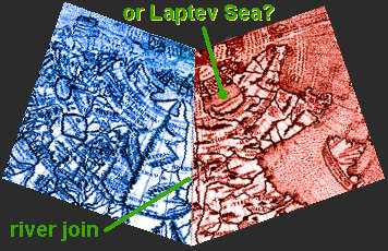 Well, probably not. If you cut the paper cone in a different place, and join the pieces together along their outer edges, you see a very different picture. First, it's clear that the pieces are meant to be joined- rivers cross from one section to the other, and in the south (not shown on the details here), two pieces of island both labelled as "part of Seylan" fit snugly together. Then, once you accept that you're really seeing Asia with a bit of North American information superimposed, you should consider the strong possibility that "Hudson's Bay" is really the Laptev Sea, on the north coast of Siberia, probably known to Asian geographers for centuries. (Actually, Hudson's Bay really was known to Europeans long before his visit; its existence seems to have been reported quite early in the European exploration of North America by traders from the First Nations, so many early maps show the south end of the Bay but try to avoid guessing about its northern opening to the sea). Various versions of the full Ruysch map can be seen on the Web. This web page has the advantage of showing Ruysch's map alongside some of its near-contemporaries. 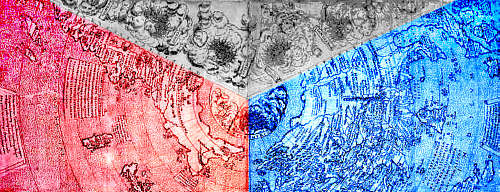  Giovanni Contarini's map, for example, uses the same projection, but is slightly earlier- 1506. If you do the same cutting-and-rotating trick with this map, you can see that its depiction of the Asian landmass is essentially derived from the sort of Ptolemaic concept used by Martellus, complete with "Dragon's Tail" (as discussed on the previous page) but with the north-eastern cape added. Giovanni Contarini's map, for example, uses the same projection, but is slightly earlier- 1506. If you do the same cutting-and-rotating trick with this map, you can see that its depiction of the Asian landmass is essentially derived from the sort of Ptolemaic concept used by Martellus, complete with "Dragon's Tail" (as discussed on the previous page) but with the north-eastern cape added.Following newsgroup discussions, another researcher has discussed the Contarini map, with photos- including the paper cone. | ||
 | 
|