This page contains a miscellany of extracts and abstracts relating to bridges around Eskdale and Miterdale, not all of which I can currently identify.
From "A Survey of the Bridges in the County of Cumberland 1764"
(Photocopy on Whitehaven R.O. library shelves, with Percy Survey- original in Leconfield archive)
[This survey did not cover all bridges in the county, only those maintained at county expense]
Mill Bridge (over Mite near Ravenglass): surveyed June 26: main arch, 26ft long, 7ft 8in wide "between the Battlements"; north arch (about 4 yds from main arch) 7ft 8in long; south arch (about 4 yds from main arch) 4ft long. Battlements 2ft 4in high, 9in thick, total length (both sides together) 126ft, "made of small walling Stones and Lime with a Course of Cape Stones" 4.5in thick- they "are or have been cramped together with Iron Cramps" about 6.5in long- 11 of these remain, but another 18 have been removed. 21 feet of "Cape Stones" also missing.
Esk Bridge "over the River Esk in Eskdale": surveyed Aug 9: 1 arch 87ft 6in long, 6ft 6in wide between battlements. Battlement height 1ft 8in, thickness 9in, length (both sides together) 102 ft- made of "Cobble Stones set End ways up and Lime". About 3yds of battlements "thrown down", some other repairs needed. Nearest lime about 14 miles; stone about 1 mile; estimated repair cost 10s.
"Conditions of letting the widening and repairing the Bridge over the River Esk near Penny Hill"
(in Carlisle Record Office bundle D/NT/9)
"Wool Pack Inn Eskdale April 5th 1817
Proposed to be lett by William Bateman and Joseph Sharpe this present Evening the widening and repairing of a Bridge over the River Esk in the Road leading from Penny Hill in Birker to the main road in the Valley of Eskdale, The Conditions are as follows, namely, The said additional Erection is to be five feet wide added to the high Side of the Bridge, and the Span or Arch is to be uniform and of a regular Sweep with the old Arch.... The Fences or Ledges on both Sides of the Bridge to be built up 3 feet high and 12 inches thick...."
To be finished by 5 Jul 1817, then maintained for 12 months.
Contract let to Matthew Russel and Joseph Braithwaite for Ł14/12/-
Bridge information in the records of Cumberland's Justices of the Peace
(all documents at Carlisle Record Office)
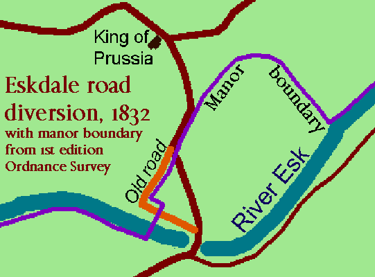
1832: proposed diversion of road to bridge over River Esk near "Moor Wood" (aka the King of Prussia Inn), with plan (which shows boundary of Birker/Austhwaite & Eskdale suggesting probable old course of river). (ref. Q11 1832 Mich/48-51)
1810: Diversion of road south of Muncaster Mill bridge (about 100 yds)- old route ran from that point just east of Barrow Farm, then curved to run just east of Cranklands Farm (approx summit of route) before joining road from Ravenglass. Revised route goes to west of farms, joining Ravenglass road c150yds further W. Old route described as "steep and difficult with natural springs". (ref. Q11 1810 Easter/75-81)
Bonds for repair and maintenance include:
1713: Repairing bond for Long Bridge at Hardknott Foot (with rebuilding bond for Cleator Bridge & others)
1754: Rebuilder's maintenance bond for Stonepott Bridge, over the Esk (in Eskdale parish), which had been rebuilt on petition of "the Inhabitants of Austhwaitefield and Eskdale".
(ref. CQAB/4)