PastPresented.info

A.R. DWERRYHOUSE ON ESKDALE GRANITE


To Eskdale index 

This is an extract from a paper titled "On Some Intrusive Rocks in the Neighbourhood of Eskdale (Cumberland)", by Arthur Richard Dwerryhouse D. Sc., F.G.S., published in the Quarterly Journal of the Geological Society, vol. lxv, February 1909. Other sections of the paper deal with the mineralogy and crystalline structure of the granite (with black-and-white microphotographs)

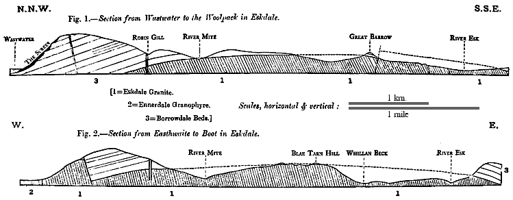
The granite is intrusive in the lavas and ashes of the Borrowdale Series, and its line of junction with these rocks is well seen at intervals along its north-western, northern, south-eastern, and eastern margins; but to the westward both the Borrowdale rocks and the granite are covered unconformably by the Trias (St. Bees Sandstone).

For a distance of about half a mile, from the foot of Wastwater to Easthwaite Farm, the granite is in contact with the Buttermere and Ennerdale Granophyre recently described by Mr. R.H. Rastall [Quart. Journ.Geol. Soc. vol. lxii (1906) pp. 253-73]. From the foot of Wastwater the boundary runs due south up the steep slope by Pens End on to the shoulder of Whin Rigg, the junction being for some distance a faulted one, and the fault-plane being occupied by a vein of ironstone. The line of fault cannot, however, be far from the edge of the intrusion, as the natural boundary comes in on the crest of the hill, and in several places on the slope the fine-grained marginal varieties of the granite, which will be more fully described hereafter, are to be seen.

The floor of Mitredale is occupied by the granite, and in Robin Gill, a tributary of the Mite, the junction of the granite and the Borrowdale rocks is seen dipping at a low angle northwards. The granite becomes increasingly finer in texture as the margin is approached, an undergoes at the same time a considerable change in chemical composition. The Borrowdale rocks are much altered, and in some places approach the condition of a mica-schist.

From Mitredale the line of junction passes along Black Gill over White Moss to Brown Band, and turns northwards by Acre Hows and Eskdale Moor to the shores of Burnmoor Tarn. It then crosses Hardrigg Gill at 1100 feet above O.D., the junction being visible in the small gorge at the head of the cascade, about 10 yards below the point where a small tributary joins the stream on its left bank. Close to the junction the granite is white with a greenish tinge, is extremely fine-grained, and contains 96.16 per cent of silica. Some 10 yards farther from the margin it assumes a pink colour, and is similar in texture to the finer specimens from Robin Gill. Specimens of the actual junction were collected, and a junction-breccia, consisting of fragments of Borrowdale lava in a granite-matrix, occurred as boulders in the bed of the stream.

Sections through the Eskdale granite
In Oliver Gill the junction occurs at about 1150 feet, the actual contact being obscured by boulders. The granite and the Borrowdale rocks may, however, be traced to within 15 yards of each other, the former showing marginal features. From Oliver Gill the boundary rises considerably, and no Blaebury How is at a height of 1350 feet. The granite is fine-grained and white: the fine-grained pink variety comes in farther from the margin and extends down to 1150 feet, gradually passing into the normal granite at lower levels.

The edge of the granite now passes along the flanks of Great How and gradually assumes a lower level, until at Whinscales Sheepfold, near the head of Brockshaw Beck, it is at a height of 1200 feet. At this point the junction dips at an angle of about 45° eastwards. The marginal zone is unusually narrow at this point, the rock in contact with the granite being a bedded ash. There is a well-marked junction-breccia here, the fragments of Borrowdale Ash between the granite-veins being remarkably angular and showing no signs of absorption (100 & 101 *).

Stony Tarn lies in a hollow in the Borrowdale rocks, the granite-boundary sweeping round to the south-west of it, and being cut off by a fault at Peelplace Noddle. Between Peelplace Noddle and the River Esk the country is much faulted, the faults carrying some haematite, being marked on the Survey-maps as metalliferous veins, and rendering the boundary somewhat intricate.

The most noteworthy features in this area are the junction-breccia, which is developed on a large scale near Whin Crag (131 & 132), and the junction near the confluence of Scale Gill with the Esk. At the latter place the granite is somewhat coarse to within a few feet of the margin, and consists of quartz and felspar, the quartz-masses in some cases attaining several inches in diameter. Close to the margin it becomes finer in texture, and is bounded by a layer of almost pure quartz (108): this is in contact with the Borrowdales, which are much altered. The junction dips at a high though variable angle south-eastwards.

The boundary passes thence by Whahouse Bridge, and crosses to the southern (left) bank of the Esk, but is not well seen until Force Gill is reached, where it is at 450 feet above sea-level, thus having fallen some 900 feet from its highest point on Blaeberry How. The actual contact in Force Gill is obscured by loose blocks which, however, include masses of the marginal varieties, from which it is assumed that the junction is a normal one and not faulted. There are in this neighbourhood many faults usually bearing ironstone, and numerous drifts where this has been worked.

The line then passes by Low Ground to the eastern end of Devoke Water, and thence for about 2 miles in a westerly direction, being faulted along this section. It then turns sharply southwards and runs along the western flanks of Birkby Fell, Knott, Stainton Fell, Wabberthwaite Fell, Corney Fell, and Prior Park, to the head of Kinmont Beck, being obscured by Glacial deposits along much of the distance. It then bends to the west, and runs nearly parallel to the road as far as Hinning House near Bootle.

At Hinning House the boundary turns northwards and abruptly changes its character, the granite being overlain by the St. Bees Sandstone on the West, and continues to the north by Wabberthwaite to the neighbourhood of Ravenglass, where in the park of Muncaster Castle the Borrowdale rocks again emerge from beneath their covering of Trias and appear in contact with the granite.

From Ravenglass the junction may be roughly located and traced by Miteside, Irton Hall, and Mecklin Park to the foot of Wastwater, but is much obscured by drift and alluvium.


* These numerals within parentheses indicate, throughout the paper, the numbers of the localities on the Author's MS. maps and of the corresponding rock specimens and microscopic slides, all deposited in the Museum of the Geological Department of the University of Leeds. Back up