Bending the boundary- 1338
| |
Many old documents survive, describing the bounds of the various manors and estates around Eskdale. But sometimes, the information given is clearly at variance with the boundaries we know today. Here are two examples from the north end of the ancient manor of Eskdale with Miterdale.
In 1209, Alice de Rumeli gave her manor in Borrowdale to Furness Abbey. The charter (quoted here from Thomas Alcock Beck's "Annales Furnesienses" 1844) described the bounds, which in the vicinity of Eskdale ran from Houedgleuermerhe [the summit or head of Glaramara] "usque ad divisas Baronie Ricardi de Luci de Egremund. Et sic per easdem divisas scilicet per summitatem montis qui dicitur Hederlangehals...":
[to the boundaries of Baron Richard de Lucy of Egremont. And so by those boundaries, specifically by the summit of the ascent called Styhead Pass...]
This was rather vague, and there aren't many more clues in a 1294 description of the boundary between Eskdale-with-Miterdale and Wasdale (summarised from the Public Record Office "Calendar of Close Rolls 1288-96"): from the place where Holegill [now Greathall Gill at the south-west end of Wastwater] falls into the Irt, along that side of Wassewater to the stream of Lesagh [there is a wood near the foot of Lingmell Beck called Liza Holm], up the stream to Ederlangebeck [the tributary flowing from Sty Head, later known as Sty Beck], up Ederlangebeck to 'le cance' [old French for a trench, so probably a feature like Skew Gill] then along the boundaries of Furness Abbey's land to the boundaries of John de Hodeleston's land.
In other words, Furness Abbey determined their bounds by reference to the bounds of the Egremont estates; the Egremont estates determined their bounds by reference to the bounds of the Furness Abbey estates (see also below). Not a good idea. But look more closely-
First, the Eskdale boundary follows the Furness Abbey boundaries all the way to John de Hodeleston's land, which means that the boundary of Borrowdale met the boundary of Furness's other local property, Brotherilkeld (i.e. it definitely went via Esk Hause).
Second, it doesn't name the junction with the Furness boundary which tends to indicate that it is nameless, supporting the identification of 'le cance' as Skew Gill, and suggesting that the Borrowdale boundary ran along the ridge immediately above the head of the Gill.
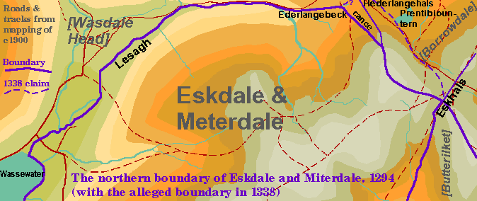
However, after the death of Thomas de Multon of Egremont, his heirs had to establish their boundaries (his widow in 1322, then his children in 1338, after her death). The 1338 boundary is much more specific- and slightly bizarre. It runs (as summarised in W.G. Collingwood's article "A few more mountain names" in the CWAAS Transactions, 1920) from Edderlanghals [Styhead Pass again] to Edderlangtern [Styhead Tarn] to Prentibiountern [which pretty much has to be Sprinkling Tarn] to Eskhals [Esk Hause]. By that reckoning, Borrowdale would be smaller by a considerable amount (admittedly mostly cliff, but including some useful sheep-pasture) than by a ridge-crest boundary.
Evidently the monks had some evidence that this was not the true boundary. 16th century boundaries of the Egremont estates (transcripts available with the "Percy Survey" at Whitehaven Local Studies Library) have the boundary following the ridge top all the way from Crinkle Crags, over Esk Hause, up to the top of Great End, down to "Stie Head" and up again to the summit of "Mickell Gavell" [Great Gable]. The same line is shown on modern maps as the boundary of Copeland District.
However, what has clearly changed since the middle ages is the boundary between Eskdale-with-Miterdale and Wasdale, which now goes up Lingmell Gill instead of Lingmell Beck, staggers over the top of Lingmell itself, then along a completely different 'trench'- Piers Gill- before heading for the western peak of Great End. I suspect that this was by agreement rather than stealth, as the land involved is so close to Wasdale Head (surprisingly, even this new boundary leaves Wasdale Head Hall- formerly known as "Fences"- in Eskdale township, but official documents such as the Tithe Award ignore this and include it with Wasdale Head).
PS: It may be worth mentioning also an agreement between the Lords of Egremont and Calder Abbey [Illustrative document 34b in Wilson, J. (Ed.) "Registrum Prioratus de Sancta Bega" (Surtees Society vol. 126, 1915)] giving the monks the right to take reasonable amounts wood etc. for their essential needs from within the Forest of Copeland, the area being defined as "de Oxlesgate versus orientam usque ad aquam de Eske et de Auesthaitbrig versus boriam usque ad rectas divisas inter dictam forestam de Coupland et de Darwent Felles..." (from Oxlesgate eastwards to the water of Esk, and from Austhwaite Bridge northwards to the rightful boundary between the said Forest of Copeland and Derwent Fells). Return to main text.