PastPresented.info

Eskdale area tithe awards


To Eskdale index 

The Tithe Commutation surveys, mostly made in the late 1830s and early 1840s, often provide a great deal of information about land ownership and use at the time. Unfortunately, the surveys for the Eskdale area have their limitations...

Eskdale with Miterdale- 1839-40
Click for enlarged details
The survey was completed on 20 Aug 1839 and the award was finally agreed on 16 Nov 1840. As the map shows, not much land in the manor of Eskdale with Miterdale was liable for tithes, except on wool & lamb- instead farms paid a small "modus". Also the estate belonging to the Rector of Eskdale, some 12 acres, was completely tithe-free.
The serious problem, however, is the map, which is an astonishingly poor piece of work, both in surveying and cartography. Nothing is in quite the right place; many features are in different places on the main map and the separate sheet of enlarged details, and there are all sorts of interesting spellings (not found in the survey document) including Towhouse/Faw House, Paddock Wreay and Borrodle Mill (for Borrowdale Place farm). I have tried to make sense of it all for the maps given here, but I offer no guarantees.
This way to the survey


>
Muncaster with Birkby- 1843
Click for enlarged details
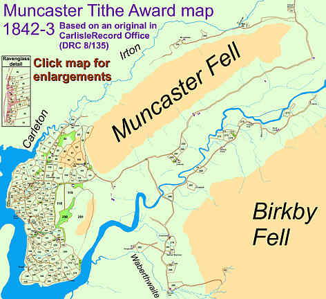
The tithe system in Muncaster parish (including Birkby) had developed along slightly different lines from that of Eskdale. Some farms in Muncaster had negotiated fixed whole-farm payments instead of tithes for individual plots, while in Birkby special arrangements had been made for sheep pastured on the open moorland.
This way to the details

The good news is that the map is a lot more reliable than the Eskdale one!

This way to the survey

Birker- 1844

As Lord of the Manor and principal landowner, Edward Stanley had effective control of tithe payments in the combined manor of Birker/Austhwaite and Brotherilkeld. This greatly simplified the tithe commutation process:

6 Apr 1844: Declaration on tithes by Edward Stanley Esq., owner of certain lands in Birker and Austhwaite, namely:
Freehold messuage & estate called the Dalegarth Hall estate (342 acres; tenant from year to year, Jonathan Rogers); freehold messuage & estate called the Brotherelkeld Estate (16,000 acres; tenant from year to year, Joseph Rogers)- consisting of "various Parcels of Land and Inclosures called Intakes lying within a walled Fence".
Of this land, 16,070 acres is meadow and pasture; 95 acres is arable; 177 acres is woodland.
"the said Tithes shall from henceforth be absolutely merged and extinguished in the Freehold and Inheritance of the said Messuages Estates Lands and Premises according to the provisions in that Behalf contained in a Statute made in the Reign of His late Majesty King William the Fourth intituled 'An Act for the communtation of Tithes in England and Wales'."
Confirmed by Tithe Commissioners, 29 May 1846.

(document in Whitehaven Record Office, D/Pen/bundle 74a)