ESKDALE IN BADDELEY'S GUIDE, 1886
![]() M.J.B. Baddeley's volume on "The English Lake District" in Dulau & Co's "Thorough Guides" lived well up to the series title, and the Eskdale information from the 4th edition (1886) is presented here in three sections.
M.J.B. Baddeley's volume on "The English Lake District" in Dulau & Co's "Thorough Guides" lived well up to the series title, and the Eskdale information from the 4th edition (1886) is presented here in three sections.
PAGE |
Scafell Pike, in itself, worthily supports its adventitious fame as the monarch of English mountains. Though not so fascinating in outline, or individually conspicuous as several others in its immediate vicinity, it has so much rugged grandeur about it- it is such a perfect example of the wildest workings of Nature- that no one who ascends it can fail to acknowledge that he has obtained one of the genuine mountaineer's first objects- the farthest pessible removal from the associations of his every-day life. Indeed, with the exception of the Coolin hills, in Skye, it is doubtful whether the British Isles contain anything more majestically wild than the region of Scafell Pike and Scafell. | |
MICKLEDOREBetween Scafell Pike and Scafell itself, and a few hundred feet below the respective summits, is a razor-like ridge called Mickledore, steep on both sides, but quite easy to walk along. On the Scafell side of this the crags rise in sheer precipices. There is a narrow opening a few yards to the left of the ridge, as it is traversed from Scafell Pike, called Mickledore Chasm. Through this opening, tourists, who wish to ascend both heights in the same journey, occasionally squeeze themselves, and then, climbing up the slanting rock above, which is ironically named the "broad stone," avoid the detour which it is otherwise found necessary to make. The route, however, is not one which the author of any guide-book would be justified in recommending, and a slip in the awkward part would be followed by disastrous consequences. | |
SAFETYThere are many ways of ascending Scafell Pike, safe and easy, though fatiguing, in clear weather; but the peculiarly rough nature of the summit, and the crags and precipices which abound on almost every side, render it a particularly dangerous mountain for anyone, who is not intimately acquainted with the district, to attempt in bad weather. | |
PONY ASCENTSPonies may be taken from Dungeon Gill, Rosthwaite, or Wasdale Head to within twenty minutes of the summit. Charge for pony and guide, about 15s. The Mason's Arms, at Boot and the Woolpack are small inns, and do not provide ponies. Routes 1, 2, and 3 are marked by path or cairn all the way; route 4 by an indifferent and slightly intermittent track, as far as the steep climb to Mickiedore.The Wasdale Head route is the easiest as well as the shortest. | |
ROUTES FROM LANGDALE AND BORROWDALE1 and 2. From Dungeon Gill or Rosthwaite:- These routes converge on the summit of Esk Hause.Route 2- A saving of more than half a mile in distance, but of no time, may be effected by ascending Grain Gill from Stockley Bridge, keeping the side of the beck, and, where it divides into two, the right-hand branch. There is no regular track. If the regular footpath route by Sty Head Tarn be taken, branch off to the left after passing the tarn, along the Wasdale Head and Langdale track, boggy at first, but soon clearly marked. Sprinkling Tarn is passed on the left, and the crags of Great End tower over the pass on the right. Instead of proceeding to the cairn on Esk Hause, work round Great End, obtaining, as you do so, a splendid view of Borrowdale and Derwentwater through the vista of Grain Gill. | |
Esk Hause to the summitFurther description applies to the two routes equally:From the summit of Esk Hause [SEE NOTE], when you begin to look down into Eskdale, the Scafell track is seen rather to the right, climbing a comparatively green "corrie" between Great End and another rocky height, which is the eastern buttress of Scafell Pike. In a few minutes a streamlet is crossed- the last water during the ascent. Then the Pillar, Steeple, and Mosedale Valley come into view in front. In another ten minutes the path becomes a chaos of rough stones, and continues so almost all the way to the summit. It is marked by small cairns placed at frequent intervals, and kept in existence by the addition continually made to them by passers by. Ponies cannot be tsken beyond the commencement of this stone pavement. The first portion of it is succeeded by an almost level stretch of gravel, scantily covered with herbage. Then come the big stones again, and a slight dip and a beautiful peep of Crummock Water on the right, through the depression between Great Gable and Kirkfell. Another and a greater dip has to be made, and then, by a steep climb of ten minutes up a narrow ridge with a plain winding path, the summit is reached. | |
ROUTES FROM WASDALE AND ESKDALE3. From Wasdale Head. (ROUTE OMITTED HERE)4. From the "Woolpack" or Boot, Eskdale:- | |
Getting to the startThe little railway which covers the seven miles between Ravenglass and Boot has fairly opened up this ascent of Scafell Pike. It is considerably longer than that from Wasdale Head, but full of interest the whole way, and though there is some "stiff" climbing during the last hour, there is nothing to appal even a timid mountaineer. During the journey, the beauties of Upper Eskdale and the crags which form the southern buttress of the Pikes and Scafell itself, are seen to the greatest advantage.The tourist may with tolerable certainty depend on accommodation during the previous night at one of the little Eskdale inns, the Mason's Arms at Boot, or the Woolpack, a mile higher up the valley, or, by leaving Drigg or Seascale by the first train, he may get away from Boot in good time. | |
The route from BootThe main road up the valley must be followed for 1 3/4 miles from Boot, and thence a private road to the left, indicated by a sign-post, to Taw House, a long half-mile further. Beyond Taw House a cart track crosses some fields, keeping the river on the right, to a couple of sheep-folds, 100 yards or so beyond which it crosses a beck by a stone bridge. Here are a couple of beautiful falls, one above and the other below the bridge. The pyramidal summit in front, which fills up the head of the valley, is Bowfell. Beyond the bridge, the road, which is now a peat track, leaves the valley, and zigzags up the steep slope on the left. When it comes to an end at a peat bog, after about half-an-hour's walk, cross some swampy ground a little to the right of its most depressed part. In a few minutes indications of a foot-track re-appear, which must be followed over comparatively level ground for a couple of miles, care being taken not to descend into the moss at the side of the river when the latter again appears on the right. The crags of Scafell tower nobly on the left. A couple of sheep-folds, and some huge detached boulders, overgrown with moss, ling, and bog myrtle, are passed. Then a stream is crossed, with a cataract called Cam Spout pouring down on the left. This stream descends from Mickledore, the ridge which connects Scafell Pike with Scafell, and to the top of which a sharp climb must now be commenced. The best plan is to work round the steep hillock just beyond Cam Spout, and then ascend underneath the crags of Scafell on the left. Twenty yards or so before the top of the ridge is attained, an opening in the rock on the left, just wide enough to squeeze through sideways, leads to the so-called Broad Stone, the short but dangerous cut from Scafell Pike to Scafell. The top of the Mickledore ridge is narrow but not dangerous, and from it a direct descent may be made into Wasdale. The summit of Scafell Pike rises directly to the right, and will be reached after another twenty minutes' hard climb over a course in comparison with which the ruins of Petra would be smooth walking. It should be added that after Cam Spout is passed all trace of a path vanishes. | |
Alternative route from BootFrom Boot to the summit of Scafell Pike there is a shorter route by which a sound-winded pedestrian may reach the top in about 2 1/2 hours. It passes by Gill Bank on the east side of the stream which descends from Burnmoor Tarn, and, having Eel Tarn on the right, joins the Eskdale route about where the peat track before-mentioned ceases. The "patentee" of this route is the postmaster at Boot, who should be consulted at starting. By its adoption, however, the beauty of mid-Eskdale is lost. There is no regular track between Gill Bank, three quarters of a mile from Boot, and the peat track. | |
VIEW FROM THE TOPThe prospect from the summit of Scafell Pike is not so good as that from many other points in the same range, which are fortunately within easy reach of it. Consequently the tourist will do well to devote a long day to the excursion. It is little over a mile, as the crow flies, from the Pike itself to Great End, its north-eastern buttress, and there is no intervening depression of more than a few hundred feet. Generally speaking, the view increases in interest all the way; Borrowdale and Derwentwater coming more and more into the line of it, and Windermere revealing itself more fully over the Langdale Valley. The only strong points lost being the view of the cliffs of Scafell itself, and the wide champaign of land and sea beyond them.The prospect is more of a mountain than a lake one. Only the lower end of Wastwater is visible, one side of Derwentwater, and a strip of Windermere; but Skiddaw and Saddleback beyond Derwentwater, Great Gable on the other side of Wasdale, and the Pillar at the head of the Mosedale Valley in the north-west, are grand objects. Grisedale Pike rises over Great Gable, whose cairn exactly cuts the line of the summit of Robinson. Between Great Gable and the Pillar is Kirkfell, beneath which, and close at hand the craggy top of Lingmell is just visible. Between Grisedale Pike and the Pillar the chief heights arc Grasmoor, with its red burly front, and the Buttermere fells of High Stile and Red Pike. On both sides of the last-named group are the Solway Firth and Scotland. The range of the Pillar is continued westwards by Steeple and Haycock, the latter rising over Low Tarn. Then comes Seatallan, sinking gradually to the crags of Buckbarrow, which, in their turn, drop abruptly to the plain of West Cumberland. The Isle of Man rises out of mid-ocean beyond Scafell, and Black Combe and the Duddon estuary arc seen to the left of the same mountain, and in close proximity to the "tall chimley to Barrow," as we once heard it called by an old lady, whose nerves had been sadly upset by the general desolation of the scene. "Something that spoke of life," was the one thing she craved for. Almost due south, to the left of the Duddon estuary, the Coniston range appears, which is continued nearer at hand by Crinkle Crags and Bowfell. Then comes a "peep" of Windermere, with the Yorkshire fells far away in the south-east, the flat- topped Ingleborough rising slightly above his fellows. Parts of the High Street range are distinguishable behind the nearer ridge of Fairfield and the Red Screes. The top of Ill Bell, its most southerly Peak, just cuts the line of Harter Fell beyond itself; then the range, disappearing to the north of Red Screes, is continued by the long, slightly-curved top of High Street itself, and the sharp point of Kidsty Pike. In the gap between Fairfield and Helvellyn, St.Sunday's Crag appears, and between the long Helvellyn ridge and Saddleback, the eye wanders away to the Eden valley, and the almost level skyline of the Pennine range. | |
DESCENTSDescents 1 and 2. To Dungeon Gill or Rosthwaite. (ROUTES OMITTED HERE)3. To Wasdale Head. (ROUTE OMITTED HERE) 4. To the Woolpack Inn or Boot (Eskdale):- This is a long but very interesting walk. There is no track whatever until the bottom of the valley is reached. From the summit make for the ridge of Mickledore between the Pikes and Scafell itself. On attaining the far side of this, go down the screes on the left, a steep but safe descent. At the foot of them, it is well to work a little to the left round a hillock, from the base of which a cataract, called Cam Spout, will be seen, descending from Mickledore. Cross the stream near the foot of this, and then keep well up by a faintly marked track, with the boggy land between it and the Esk river on the left. You will pass some big over-grown boulders. Where the stream flows farther away to the left, keep stralght on, passing by two sheep-folds. Half-an-hour's more walking will bring you to a peat bog, whence a cart track zigrags down to the bottom of the valley, crossing a bridge, on either side of which are beautiful falls, near the bottom of it. Hence the route goes through two more contiguous sheep-folds, and, passing the farmstead of Taw House, enters the main Eskdale road about 3/4 mile beyond it, and a like distance short of the Woolpack. A correspondent assures us that the route by Esk Falls is equally good. | |
ESK HAUSEEverything is perfectly plain in clear weather, but if the clouds are about (and no place we fancy would have been dearer than Esk Hause to the "cloud-compeller" of the Homeric story) the tourist will do well to remember the following facts:-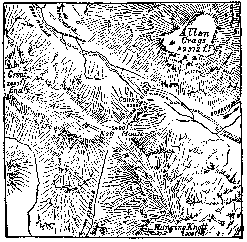 Esk Hause is the depression between Great End and Hanging Knott, portions of the Scafell and Bowfell groups of mountains respectively, both of which are kept on the right during the whole of the present route. Its summit (2,490 ft.) is the watershed of Borrowdale to the north, and Eskdale to the south. Consequently the track from Wasdale to Langdale, which bears, generally speaking, from west to east does not actually cross the main ridge, but runs parallel to it, a few hundred yards on the Borrowdale side, and about 100 feet below the level of the hause itself. Oddly enough, the waters from both sides of the lateral ridge which our present route crosses, though starting in exactly opposite directions, find their way into the same valley- Borrowdale- and it is probably ignorance or disregard of this fact which has caused so many people to go wrong at or about this particular spot, when from bad weather or other causes they have lost sight of the path. These remarks will, we hope, be rendered intelligible by the subjoined map. (BACK UP)
|